

 By
By 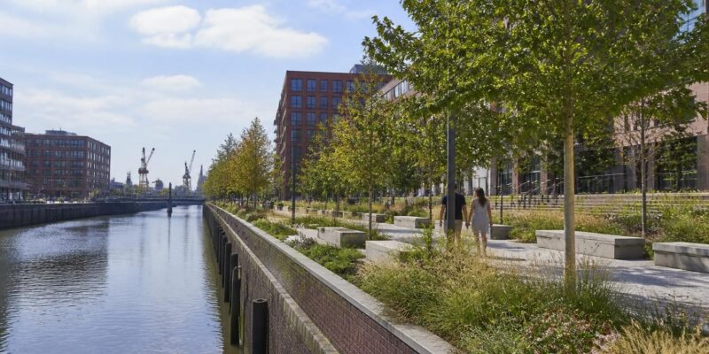
Hamburg has opened a new public waterfront route in Harburg, turning a former harbour-side stretch into a green promenade for walking, cycling and everyday urban life. The Harburger Brücken green corridor was formally inaugurated on Friday, 28 August, in the Harburg Binnenhafen district.
The project links the areas around Karnapp and Veritaskai along the eastern Bahnhofskanal. It is intended to strengthen connections between the growing harbour quarter and Harburg’s central areas while providing a more inviting place to pause beside the water. The opening was attended by Hamburg’s Senator for Urban Development and Housing, Karen Pein, and Harburg district chief Christian Carstensen. ([hamburg.de](https://www.hamburg.de/politik-und-verwaltung/bezirke/harburg/aktuelles/pressemeldungen/gruenzug-harburger-bruecken-fertiggestellt-1202482?utm_source=openai))
A public route through a changing harbour district
Harburg Binnenhafen has been changing from a largely industrial and commercial landscape into a mixed urban district with housing, workplaces, cultural uses and public spaces. In that setting, the new promenade is more than a landscaped path. It forms part of a wider network of routes and open spaces intended to make the waterfront easier to reach and more useful throughout the day.
The route follows a curved alignment through a landscaped area, with a grassed embankment beside the canal, new trees and shrubs, and elements recalling the site’s harbour history. A restored listed quay wall forms a central feature. Around that section, the path widens, creating additional room for movement and informal stays. The design also connects with existing green routes approaching from the direction of Theodor-Yorck-Straße. ([hamburg.de](https://www.hamburg.de/politik-und-verwaltung/bezirke/harburg/aktuelles/pressemeldungen/gruenzug-harburger-bruecken-fertiggestellt-1202482?utm_source=openai))
For residents, the practical benefit is a new continuous public connection along the water. For visitors, it offers a way to experience Harburg’s industrial character without separating the waterfront from the rest of the district. The project’s combination of pedestrian and cycling space reflects a broader urban-planning question: how can former working landscapes accommodate new neighbourhood life without losing their identity?
Designing for heat and heavy rain
Climate adaptation is built into the promenade’s planting and drainage strategy. Hamburg says the scheme uses climate-resilient trees selected to provide natural shade as they mature. The planting areas include improved soil structures intended to give roots more space and better long-term growing conditions.
Rainwater is also treated as a resource rather than simply being carried away. So-called sponge-city drainage elements and underground systems are designed to retain and direct precipitation towards the trees. The approach can help support vegetation during dry periods while reducing the pressure placed on conventional drainage during heavy rainfall.
Such measures are increasingly relevant in dense waterfront districts, where large paved surfaces, exposed building façades and limited shade can intensify summer heat. The Harburger Brücken project is comparatively local in scale, but its design illustrates how public-space upgrades can combine mobility, recreation and environmental functions instead of treating them as separate investments.
Part of a larger open-space network
The new green corridor is being developed within the broader integrated neighbourhood programme for Harburger Binnenhafen and Neuland-Nordwest. The local development framework identifies public routes and open spaces as important elements in the district’s transformation. The Harburger Brücken promenade joins other public paths and spaces in the harbour area, including the Schlossinsel, the Gebrüder-Cohen-Park, the Lotsekai, the Dampfschiffsweg and the Treidelweg. ([harburger-binnenhafen.de](https://harburger-binnenhafen.de/?utm_source=openai))
This network approach matters because a single attractive waterfront segment can remain isolated if it is difficult to reach from surrounding streets or neighbourhoods. By linking the promenade to existing routes, the project aims to make the harbour more permeable for people travelling on foot or by bicycle.
The scheme also shows how urban renewal can work with traces of the past. Rather than presenting the waterfront as a blank, newly polished surface, the design retains harbour references and the historic quay wall. That combination gives the route a distinct local character while allowing it to serve contemporary needs.
A modest intervention with a wider urban purpose
The opening of Harburger Brücken does not resolve every challenge facing a growing district. It does, however, provide a completed piece of public infrastructure at a moment when many urban areas are seeking practical ways to improve everyday access to nature, water and low-traffic routes.
Its significance lies in the overlap of several functions: a promenade for walking, a route for cycling, a landscape for planting, a place to encounter harbour heritage and a small component of Hamburg’s climate-adaptation agenda. That combination gives the project relevance beyond Harburg itself.
As the trees mature and the wider harbour network develops, the new route will show how much a carefully designed public edge can contribute to a neighbourhood. The project’s central idea is straightforward: make the waterfront easier to use, greener to experience and better connected to the city around it.

















Comments