

 By
By 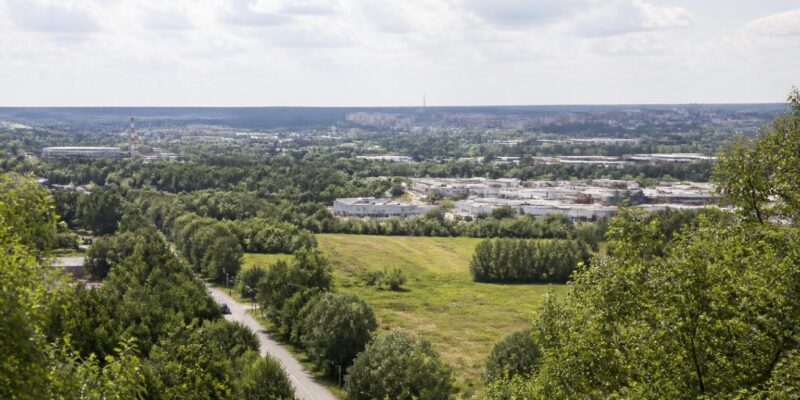
A long-reserved area gets a new urban role
Vilnius has published a development concept for approximately 220 hectares of land in the Rasos and Naujininkai neighbourhoods, opening a new chapter for one of the least urbanised large areas in the southern part of the capital. The municipality says the territory, long kept in reserve for possible airport expansion, can now be planned as a coherent urban district focused on industry, logistics, business and commercial activity.
The announcement, issued on September 14, is not a detailed development plan or a construction permit. Instead, it sets out the broad principles that future detailed plans will have to follow. The approach is intended to prevent individual plots from being developed in isolation and to establish a shared framework for streets, green areas, public spaces and engineering networks.
From airport reserve to planned city structure
The area became available for wider planning after the city moved away from the idea of building an alternative runway for Vilnius International Airport there. For decades, that reservation limited the range of possible uses and made long-term investment more difficult. The new concept gives the municipality, landowners and prospective investors a clearer basis for discussing the area’s future.
According to the city, most of the territory would accommodate industrial and warehousing uses, with opportunities for business and commercial buildings. Offices and other customer-facing activities are proposed closer to the principal transport corridors, while larger warehouses would be placed further away from the main streets. The intention is to create a more legible urban edge rather than a collection of unrelated industrial compounds.
The concept proposes buildings generally up to 16 metres high, with buildings of up to 20 metres envisaged in a central area near Liepkalnio Street. Final heights would still have to take account of the existing terrain, airport protection zones and the requirements of responsible public authorities.
Green connections and a buffer for nearby neighbourhoods
Green infrastructure is one of the main elements of the framework. The planning material takes account of state-owned forests and other wooded areas, while identifying separate green spaces, planted connections and areas where landscape features should be integrated into future development.
In the southern part of the territory, green belts are intended to form a buffer between future industrial or warehousing sites and existing or planned residential areas further south. This would preserve ecological links while creating a gradual transition between different types of urban land use.
The proposal also leaves room for shared-use areas and internal public spaces within larger blocks. That distinction matters because the municipality is presenting the future district as a functioning part of Vilnius, rather than simply a zone for production halls, depots and storage buildings.
Transport and utilities must develop together
The territory currently lacks a complete network of centralised water supply, wastewater collection and surface-water systems. Electricity infrastructure would also need to be strengthened before substantial urbanisation could take place.
The concept therefore includes an internal street network connecting future blocks and linking them to existing major roads. The city says streets, utilities and new development should be planned together, allowing access, drainage, energy supply and water management to be addressed as one system.
This is particularly relevant for a district expected to carry industrial and logistics traffic. A coordinated street layout could help prevent heavy vehicles from being routed through nearby residential streets, although the precise traffic solutions will only become clear in later planning stages.
Public presentation scheduled for September 28
Residents, landowners, business representatives and other interested parties will be able to review the concept during an online presentation on September 28 at 17:30. The meeting will be held through Microsoft Teams, with registration required. The municipality says questions can be submitted in advance and that time will be reserved for discussion after the presentation.
For Vilnius, the announcement marks the start of a planning process rather than the completion of a development project. The next stages will determine how individual parts of the 220-hectare area are divided, how access roads are designed and how green and public spaces are protected. The immediate significance is that a previously constrained area now has a citywide framework for gradual transformation.











Comments